Map Illustrators
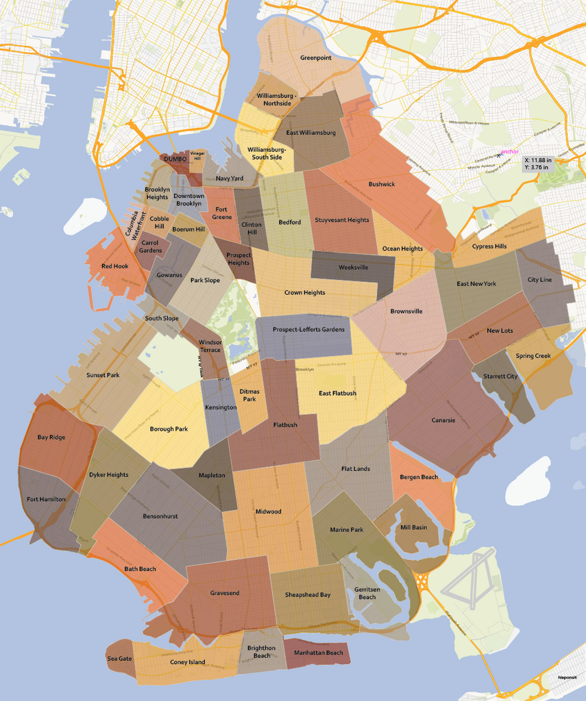
Brooklyn Neighbourhoods Map
Brookly, New York, USA neighbourhood map in vector file format you can edit in your own design software. Your topographic plan at street level contains editable layers for each cartographic category like roads, rivers, points of interests et cetera. This Brooklyn Map includes all the neighbourhoods and their borders.
Only accept the most accurate map of Brooklyn. This is what makes Map Illustrator stand out from other suppliers.
Specifications of the Brooklyn Neighbourhood Map
- File format: Adobe Illustrator CC, other file formats like .jpg, .pdf, .png or .eps are available on request
- File size: 5 MB
- Scale: 1:25.000
- Publishing date: 2017
- Online delivery by downloadable link
Benefits
- Save money: save tremendous time and money designing or printing your own city map
- No surprises: up-to-date, complete and high-resolution cartography
- High quality: scale, crop or zoom to virtually any size without loss in detail or quality
- Copyright free: buy once, use as much as possible
- No risk: 30 days money back guarantee, no questions, no hassle
Brooklyn Neighbourhoods
Northwestern Brooklyn
Brooklyn Heights
Brooklyn Navy Yard
Admiral's Row
Cadman Plaza
Clinton Hill
Downtown Brooklyn
Bridge Plaza/RAMBO
DUMBO
Fort Greene
Fulton Ferry
Pacific Park/Atlantic Yards
Prospect Heights
Vinegar Hill
South Brooklyn – takes its name from the geographical position of the original town of Brooklyn, which today includes the neighbourhoods listed above under the heading "northwestern Brooklyn." It is not located in the southern part of the modern borough.
Boerum Hill
Carroll Gardens
Columbia Street Waterfront District
Cobble Hill
Gowanus
Park Slope
South Park Slope
Greenwood Heights
Red Hook
Northeastern Brooklyn
Bedford–Stuyvesant
Bedford
Ocean Hill
Stuyvesant Heights
Central Brooklyn
Crown Heights
Weeksville
Ditmas Park
Flatbush
Beverley Squares: Beverley Square East, Beverley Square West
East Flatbush
Farragut
Fiske Terrace
Pigtown
Prospect Park area
Kensington
Ocean Parkway
Prospect Lefferts Gardens
Prospect Park South
West Midwood
Windsor Terrace
Wingate
Midwood
Western Brooklyn
The southwestern portion of Brooklyn shares numbered streets and avenues starting from 36th Street to 101st Street and from 1st Avenue to 25th Avenue, passing through the neighbourhoods listed below, respectively.
Bath Beach
Bay Ridge
Bensonhurst
Borough Park
Dyker Heights
Mapleton
New Utrecht
Sunset Park
Chinatown
Sunset Industrial Park
Southern Brooklyn
Barren Island
Bergen Beach and Georgetown
Coney Island
Brighton Beach, also known as "Little Odessa"
Manhattan Beach
Sheepshead Bay and Madison
Sea Gate
Flatlands
Gerritsen Beach
Gravesend
White Sands
Homecrest
Marine Park
Mill Basin
Plumb Beach
Eastern Brooklyn
Brownsville
Canarsie
East New York
City Line
Cypress Hills
New Lots
Spring Creek
Starrett City
Highland Park
Northern Brooklyn
Bushwick
Wyckoff Heights
East Williamsburg
Greenpoint
Little Poland
Williamsburg