

Map Illustrators
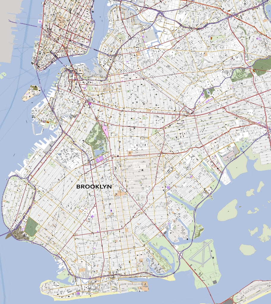
Detailed Vector Map of Brooklyn New York City
We just finished the design of one of the most detailed maps of Brooklyn, New York, USA. Due to our map design process where we use local sources and high-resolution satellite images, we are able to create city maps including the latest changes at street level.
Brooklyn - New York City Map
Save days of work and so thousands of dollars using our detailed Brooklyn City Map in your design. Your topographic plan at street level contains editable layers for each cartographic category like roads, buildings, rivers, points of interest et cetera. This Brooklyn City Vector Map includes not only the centre but all Brooklyn neighbourhoods. That is what makes Map Illustrators stand out from other suppliers. Please contact us if you need a custom-made vector city map of other parts of New York.
Specifications of the Vector Brooklyn Map
- File format: Adobe Illustrator CC, other file formats like .jpg, .pdf, .png or .eps are available on request
- File size: 8 MB
- Scale: 1:7.100
- Publishing date: 2017
- Online delivery by downloadable link
Benefits
- Save money: save tremendous time and money designing or printing your own city map
- No surprises: up-to-date, complete and high-resolution cartography
- High quality: scale, crop or zoom to virtually any size without loss in detail or quality
- Copyright free: buy once, use as much as possible
- No risk: 30 days money back guarantee, no questions, no hassle
New York City facts
New York City (also referred to as "New York", "NYC", "The Big Apple", or just "the City" by locals), is the most populous city in the United States. It lies at the mouth of the Hudson River in the southernmost part of the state, which is part of the Mid-Atlantic region of the U.S. The city spans a land area of 305 square miles (790 km2). New York City has a population of approximately 8.2 million people. The New York Metropolitan Area, which spans lower New York, northern New Jersey, and southwestern Connecticut, has a population of 18.7 million, making it the largest metropolitan area in the U.S. As of 2007, it was 5th in the world, after Tokyo, São Paulo, Mexico City and Seoul.
New York City is a centre for media, culture, food, fashion, art, research, finance, and trade. It has one of the largest and most famous skylines on earth, dominated by the iconic Empire State Building. New York City is the business and financial capital of the world, and many leading national and international corporations have their headquarters there. The city's financial centre, Wall Street, is the world's leading centre of finance and the home of the nation's most important securities market, the New York Stock Exchange. The same area contains the nation's second largest exchange, the American Stock Exchange, and several smaller exchanges, including the Commodity Exchange, which deals in metals, rubber, and hides; the Coffee, Sugar, and Cocoa Exchange; the Cotton Exchange; the Futures Exchange; the New York Mercantile Exchange; and the International Monetary Market.
In addition, in the vicinity of Wall Street are many of the nation's biggest banks, trust companies, insurance companies, and brokerage houses. Because of its favourable location, excellent port facilities, and large population, New York City is the leading wholesale and retail trade centre in the United States. New York is also a leader in communications, the hotel and restaurant business, building construction, and manufacturing. New York City has reinvented itself economically in the last half of the 20th century. In 1945 it was the busiest port and the most important manufacturing centre in the world. Since that time, it has lost more than 800,000 of its 1 million factory jobs. Although more than 100,000 longshoremen once worked its docks, fewer than 10,000 did so in the late 1990s. Activity on the waterfront was decimated by a combination of intense competition from other U.S. ports and technological changes such as containerization, which allow ships to be loaded and unloaded by far fewer workers.
Between 1955 and 1980, the city also lost jobs as corporations left the city, moving to nearby suburbs or to other parts of the country. Companies found that they could cut the cost of office rentals, wages, and taxes that they had paid in the city. Since 1980, however, New York has experienced an economic boom, particularly in new service industries that provide services to individuals and businesses in such fields as finance and banking, health services, education, restaurants, and sales. It has also solidified its reputation as a financial, cultural, and communications centre. New York City’s banks and law firms have prospered.
The metropolitan region’s well-paid managerial class has worked to integrate the world economy with that of the United States, through the influence of the city’s stock market, investment banks, and currency traders. New York’s stock market, the largest in the world, has a profound influence on finances around the world. In addition, the city’s investment banks are extremely influential in establishing the value of foreign firms and currencies. By the end of the 1990s, every important financial institution in the world had a presence in New York, and Wall Street had become synonymous with high finance. Manhattan is the headquarters of the nation’s television and radio networks, making it the heart of the mass media in the United States. The headquarters of most of the nation’s major publishing houses and advertising agencies are also clustered in Manhattan’s Midtown.
Brooklyn Neighborhoods
Northwestern Brooklyn
Brooklyn Heights
Brooklyn Navy Yard
Admiral's Row
Cadman Plaza
Clinton Hill
Downtown Brooklyn
Bridge Plaza/RAMBO
DUMBO
Fort Greene
Fulton Ferry
Pacific Park/Atlantic Yards
Prospect Heights
Vinegar Hill
South Brooklyn – takes its name from the geographical position of the original town of Brooklyn, which today includes the neighbourhoods listed above under the heading "northwestern Brooklyn." It is not located in the southern part of the modern borough.
Boerum Hill
Carroll Gardens
Columbia Street Waterfront District
Cobble Hill
Gowanus
Park Slope
South Park Slope
Greenwood Heights
Red Hook
Northeastern Brooklyn
Bedford–Stuyvesant
Bedford
Ocean Hill
Stuyvesant Heights
Central Brooklyn
Crown Heights
Weeksville
Ditmas Park
Flatbush
Beverley Squares: Beverley Square East, Beverley Square West
East Flatbush
Farragut
Fiske Terrace
Pigtown
Prospect Park area
Kensington
Ocean Parkway
Prospect Lefferts Gardens
Prospect Park South
West Midwood
Windsor Terrace
Wingate
Midwood
Western Brooklyn
The southwestern portion of Brooklyn shares numbered streets and avenues starting from 36th Street to 101st Street and from 1st Avenue to 25th Avenue, passing through the neighbourhoods listed below, respectively.
Bath Beach
Bay Ridge
Bensonhurst
Borough Park
Dyker Heights
Mapleton
New Utrecht
Sunset Park
Chinatown
Sunset Industrial Park
Southern Brooklyn
Barren Island
Bergen Beach and Georgetown
Coney Island
Brighton Beach, also known as "Little Odessa"
Manhattan Beach
Sheepshead Bay and Madison
Sea Gate
Flatlands
Gerritsen Beach
Gravesend
White Sands
Homecrest
Marine Park
Mill Basin
Plumb Beach
Eastern Brooklyn
Brownsville
Canarsie
East New York
City Line
Cypress Hills
New Lots
Spring Creek
Starrett City
Highland Park
Northern Brooklyn
Bushwick
Wyckoff Heights
East Williamsburg
Greenpoint
Little Poland
Williamsburg