
Map Illustrators
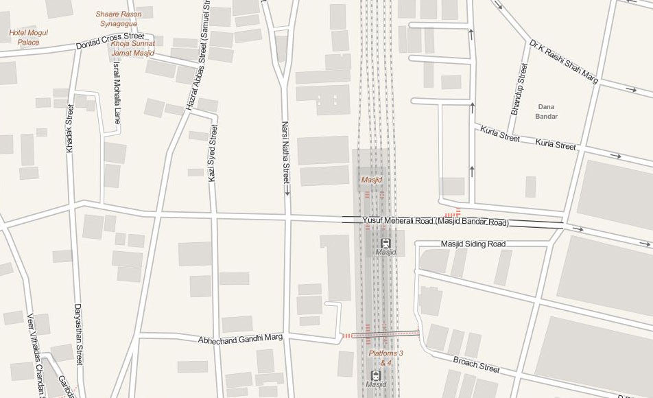
Mumbai (Bombay) City Map
Detailed Mumbai - Bombay (India) City Map In Vector File Format
Edit this accurate map in your own design software, like Adobe Illustrator. Your topographic plan at street level contains editable layers for each cartographic category like roads, buildings, rivers, points of interests et cetera. This Mumbai (Bombay) City Vector Map includes not only the city centre, but the suburbs as well.
Only accept the most accurate map. Therefore, we take one working day to incorporate the latest changes in a city map. This is what makes Map Illustrators stand out from other suppliers.
Specifications of the Vector Mumbai (Bombay) City Map
- File format: Adobe Illustrator CC, other file formats like .jpg, .pdf, .png or .eps are available on request
- File size: 15 MB
- Scale: 1:15.000
- Publishing date: 2017
- Online delivery period: 24 hours / by downloadable link
Benefits
- Save money: save tremendous time and money designing or printing your own city map
- No surprises: up-to-date, complete and high-resolution cartography
- High quality: scale, crop or zoom to virtually any size without loss in detail or quality
- Copyright free: buy once, use as much as possible
- No risk: 30 days money back guarantee, no questions, no hassle
Mumbai (Bombay) facts
Mumbai consists of two distinct regions: Mumbai City district and Mumbai Suburban district, which form two separate revenue districts of Maharashtra. The city district region is also commonly referred to as the Island City or South Mumbai.[26] The total area of Mumbai is 603.4 km2 (233 sq mi).[134] Of this, the island city spans 67.79 km2 (26 sq mi), while the suburban district spans 370 km2 (143 sq mi), together accounting for 437.71 km2 (169 sq mi) under the administration of Municipal Corporation of Greater Mumbai (MCGM). The remaining areas belong to various Defence establishments, the Mumbai Port Trust, the Atomic Energy Commission and the Borivali National Park, which are out of the jurisdiction of the MCGM. The Mumbai Metropolitan Region which includes portions of Thane, Palghar and Raigad districts in addition to Greater Mumbai, covers an area of 4,355 km2 (1681.5 sq mi). Mumbai lies at the mouth of the Ulhas River on the western coast of India, in the coastal region known as the Konkan. It sits on Salsette Island (Sashti Island), which it partially shares with the Thane district. Mumbai is bounded by the Arabian Sea to the west. Many parts of the city lie just above sea level, with elevations ranging from 10 m (33 ft) to 15 m (49 ft); the city has an average elevation of 14 m (46 ft). Northern Mumbai (Salsette) is hilly, and the highest point in the city is 450 m (1,476 ft) at Salsette in the Powai–Kanheri ranges. The Sanjay Gandhi National Park (Borivali National Park) is located partly in the Mumbai suburban district, and partly in the Thane district, and it extends over an area of 103.09 km2 (39.80 sq mi). Apart from the Bhatsa Dam, there are six major lakes that supply water to the city: Vihar, Lower Vaitarna, Upper Vaitarna, Tulsi, Tansa and Powai. Tulsi Lake and Vihar Lake are located in Borivili National Park, within the city's limits. The supply from Powai lake, also within the city limits, is used only for agricultural and industrial purposes. Three small rivers, the Dahisar River, Poinsar (or Poisar) and Ohiwara (or Oshiwara) originate within the park, while the polluted Mithi River originates from Tulsi Lake and gathers water overflowing from Vihar and Powai Lakes. The coastline of the city is indented with numerous creeks and bays, stretching from the Thane creek on the eastern to Madh Marve on the western front. The eastern coast of Salsette Island is covered with large mangrove swamps, rich in biodiversity, while the western coast is mostly sandy and rocky. Soil cover in the city region is predominantly sandy due to its proximity to the sea. In the suburbs, the soil cover is largely alluvial and loamy. The underlying rock of the region is composed of black Deccan basalt flows, and their acidic and basic variants dating back to the late Cretaceous and early Eocene eras. Mumbai sits on a seismically active zone owing to the presence of 23 fault lines in the vicinity.[149] The area is classified as a Seismic Zone III region,[150] which means an earthquake of up to magnitude 6.5 on the Richter magnitude scale may be expected.